Forecast Uncertainty for Tropical Storm Melissa and Possible Impacts for Jamaica – Dr. Andy Hazelton
Introduction
A guest blog post with Dr. Andy Hazelton.
Tropical Storm Melissa is currently over the Eastern Caribbean, and slowly getting organized. It became a TC this morning, with visible imagery and ASCAT showing a closed though asymmetric circulation.
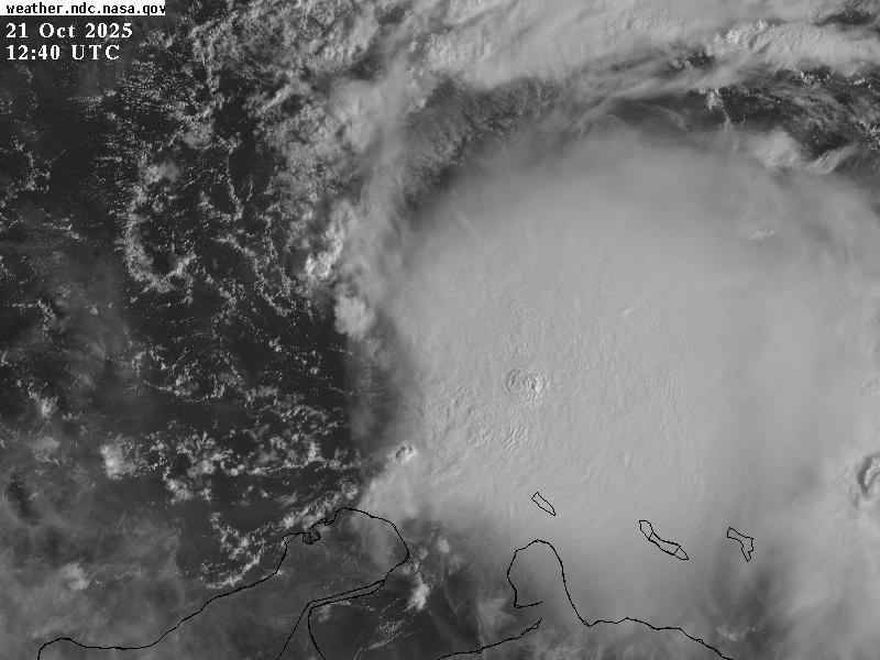
Figure 1: Satellite imagery for 98L valid at 0125 UTC October 21, 2025. Image from NASA.
Forecast Uncertainty
Models are showing a wide variety of possible solutions for the system. This can be illustrated by the Google AI DeepMind ensemble, which shows a one cluster taking the system NE towards Hispaniola, but another large cluster taking the system further west towards the NW Caribbean. Jamaica is situated between the two possibilities. Some members show a direct hit, while others show a stall or close pass for the island.
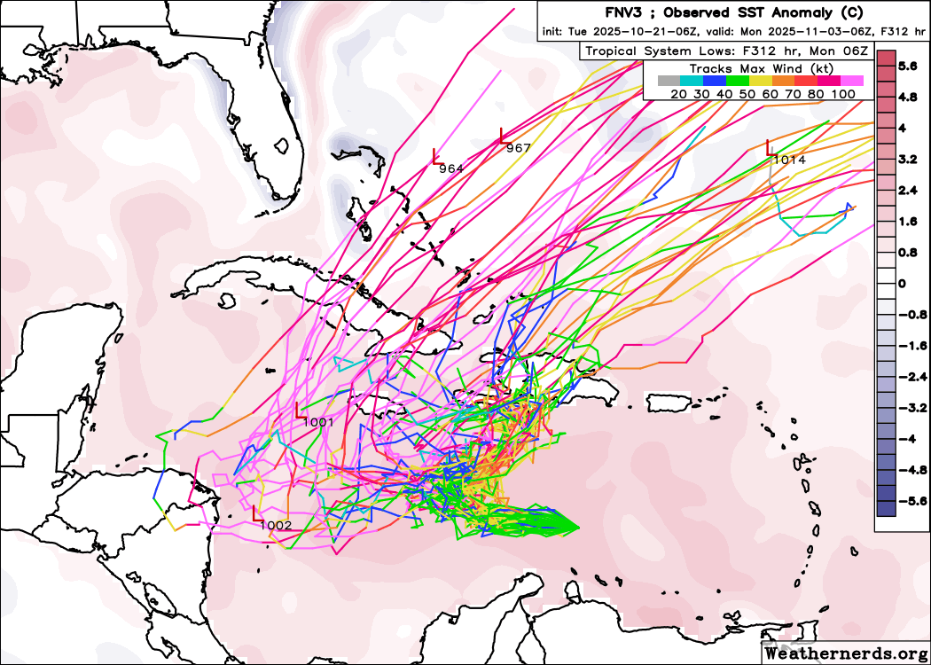
Figure 2: Google Deepmind/FNV3 ensemble of TC tracks shaded by wind speed, initialized at 18 UTC October 20, 2025, and valid out to 312h. Figure from www.weathernerds.org.
The forecast uncertainty mostly stems from the fact that the storm will be located in a weak steering zone with a trough to the northeast and a ridge to the west (Figure 3). A slightly stronger storm initially or a slightly deeper trough early on would likely result in a track closer to Hispaniola, while a slightly weaker storm initially or stronger ridge would potentially result in a more SW track.
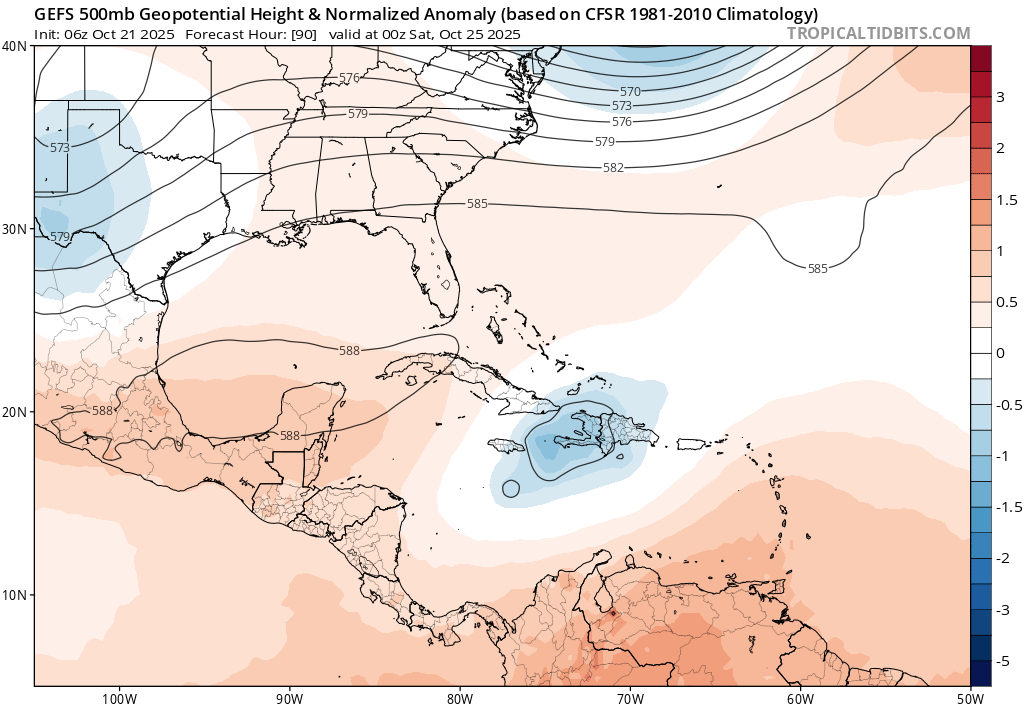
Figure 3: GFS ensemble mean forecast of 500-hPa height and anomalies initialized at 06 UTC October 20, 2025, valid at 00 UTC October 25, 2025. Image from www.tropicaltidbits.com.
Jamaica Scenarios
There are three main possibilities for Jamaica:
1) Miss to the East
If the storm follows the models that turn East over Hispaniola, impacts may be fairly minimal. This is because most of the rain and wind will be on the East side of this system, so Jamaica would be on the “clean” side. An example of this is the operational HAFS-B forecast from 00Z October 21 (Figure 4).

Figure 4: HAFSV2.1.1B forecast reflectivity initialized 00 UTC October 21, 2025, valid at 06 UTC October 26, 2025. Image from NOAA AOML.
2) Miss to the South
If the system stays weaker longer, it could get pushed west south of Jamaica. Depending on how close it gets, the storm could still get close enough for some rain and wind. Even if the storm is somewhat off to the south and west, the westerly wind shear would potentially lead to some rainfall impacts to the north and east near the island. An example of this is the 06Z HMON Model (Figure 5).
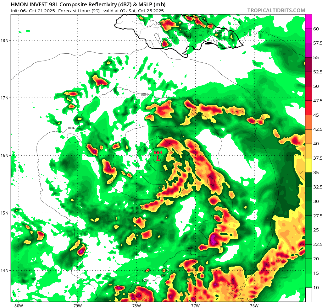
Figure 5: HMON forecast rainfall and MSLP initialized at 06 UTC October 20, 2025, valid at 09 UTC October 25, 2025. Image from www.tropicaltidbits.com.
3) Direct hit
There are a couple of ways Jamaica could end up with a direct hit. If the storm starts drifting west, it could move over or very near the island. This scenario would obviously be the most impactful. If the upper winds are favorable enough, the storm could rapidly intensify in the very warm water of the Caribbean and maybe even become a major hurricane. An earlier forecast of experimental HAFS-B showed this scenario, with hurricane force wind gusts across most of the island (Figure 6). The storm could also move to the south of the island then turn back to the northeast and pass close to or over the island. This scenario shows up on some ensemble members.

Figure 6: HAFSV2.1.1B forecast wind gusts initialized 06 UTC October 20, 2025, valid at 15 UTC October 26, 2025. Image from NOAA AOML.
Impacts
Impacts from the system will depend on how close it gets. A direct landfall would bring all of the usual TC hazards including strong winds, flooding rain, and storm surge. Even a close pass without direct landfall could cause a lot of flooding from rainbands, particularly if the storm stalls or moves slowly. As usual for Atlantic tropical cyclones, the worst weather (“dirty side”) will be the east side due to upper level winds out of the west.
Summary
There is still a lot of forecast uncertainty, but there is definitely a risk of impacts to Jamaica from Melissa. It was classified as a tropical storm this morning, and so we will get official forecasts from the National Hurricane Center. Stay tuned to their updates (https://www.nhc.noaa.gov/) and begin to prepare, hoping for the best and minimal impacts!